
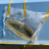
The grynns are old dammed barriers on military initiative. Correctly marked on nautical charts, but the straight lines with underwater rocks can be perceived as a cable or similar since it forms such an unnatural shape.
The only marking is half-collapsed signs where the paint has completely faded. Groundings are very common; I have seen about 10 or more myself over the years, including really large motorboats.
Weather
 Wind
Wind
 29 km/h
SW(246.7°)
 Swell
Swell
 Height
--
 Partially cloudy
 --
--
 14°C
14°C
