
The same error exists in the nautical charts for the current area.
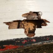
Grounding twice well within the chart’s 3-6 meter area at a long distance west of the western north cardinal mark outside the harbor. Position 57.44,417N 16.40,431E and 57.44,440N 16.40,431E. Very rapid shallowing. Reported the positions to the Swedish Maritime Administration via the website.
Have been in contact with the guest harbor owner and advised them to check the depth as the Guest Harbor Guide states that the approach is well marked from the fairway, which is not the case, we cannot be the only ones who have run aground. Contacted Lysingebadets Camping again at the end of August and they still have not checked the depths, but commented that “as far as they know, only a few other boats have run aground this summer.” Irresponsible to establish a guest harbor without checking the depth of the approach. According to reports, other sailors have brought this unmarked shoal to the camping’s attention.
Received a response from the Swedish Maritime Administration that they will make corrections with a new shoal in the Notices to Mariners and the next edition of the charts, after a hydrographic survey.
For my part, this visit cost 13,500 in deductible and over 3 weeks in the shipyard.
Weather
 Wind
Wind
 53 km/h
 Swell
Swell
 Height
 Partially cloudy
 --
--
 14°C
14°C